




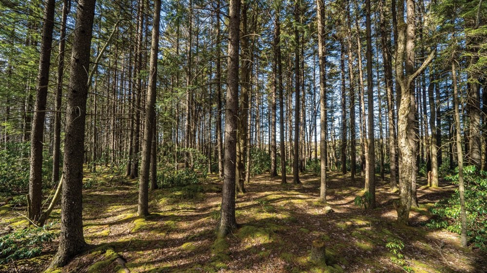
The fast-moving clouds break, permitting the sun’s rays to soak through the thick spruce canopy and bathe the mossy forest floor in golden light. A wind gust accompanies the rays, making the supersized cinnamon ferns dance as if waving hello. My mountain bike tires make a muffled yet satisfying crunch in the spruce needle duff as I drift through the forest.
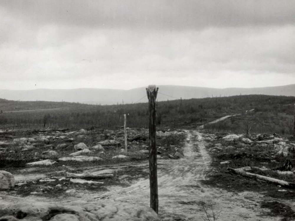
Looking east toward Cabin Mountain from a vantage point atop Canaan Mountain in 1933. A pole supporting a telephone line is visible in the foreground. Photo courtesy USDA Forest Service
I’m in the thick of the Canaan Mountain Plantation, enjoying the results of the hardworking folks who planted these now towering trees when they were six-inch seedlings precisely 100 years ago. I’ve been on this trail a thousand times, but, as it goes with most of my beloved haunts in West Virginia, it never gets old. There’s always something new to notice, like the way the light hits a mossy boulder or a unique plant tucked among the macro display of a hummock. Likewise, the familiar sights continue to evoke the same ethereal sense of awe that I experienced on my first foray.
While it may seem that this towering forest is ancient, timeless even, it was a barren wasteland just a century ago. Like most primeval forests in Central Appalachia, the sprawling red spruce forests that once covered nearly 16 million acres in West Virginia fell victim to relentless industrialization.
The first accounts from European settlers in the late 1700s described an impenetrable landscape choked with stands of 100-foot-tall red spruce trees and rhododendron hells so thick a human could not slip through them. The Canaan Valley area itself was described as so rugged and impassable that Indigenous cultures reportedly avoided the region altogether, opting to hunt and fish and farm down in the fertile river valleys thousands of feet below.
But as the clear-cutting spree of the early 1900s swept through the Allegheny highlands, even the most remote and rugged folds of these mountains could not escape the hungry sawblades of humankind. Not a single sapling was left standing on the broad shoulders of the mountains surrounding Canaan Valley.
In March of 1907, raging flood waters carrying car-sized blocks of ice inundated Pittsburgh, Pennsylvania, killing 12 people and grinding the Steel City to a halt. Investigators traced the source of the floods south across the Mason-Dixon line to the denuded slopes of the Cheat River watershed. With no trees to stabilize the steep river canyons, runoff was channeled directly into the rivers and north into Pittsburgh.
In 1914, Congress passed the Weeks Act, which authorized governmental purchase of lands for watershed and natural resource management. In April of 1920, President Woodrow Wilson signed a proclamation to establish the Monongahela National Forest with hopes of reforesting the slopes.
The first major restoration effort on the fledging national forest occurred at the northern end of Canaan Mountain, high above the sooty smokestacks and buzzing sawmills in the timber town of Davis. Encompassing a broad high-elevation plateau that reaches a high point of 4,145 feet at Pointy Knob, Canaan Mountain’s thick forests and mossy upland bogs of today are a year-round recreation destination. But this seemingly pristine paradise would be unrecognizable to the hardy men that worked the plantation camps 100 years ago. Upon their arrival they would have seen a barren landscape dotted with sandstone boulders, black with ash from the constant wildfires that burned the remaining slash and soil down to the bedrock.
I often wonder what the people of that era felt upon seeing a completely ravaged landscape. Was there a warped sense of pride for the sheer dominance of humankind over the landscape? Was there sadness or despair over the razing of these great forests? Were these men excited by the prospect of having a direct hand in reforesting Appalachia? Plantation laborers earned a wage of $2.56 per day; foremen earned $3.00 per day. Perhaps, given the standard of living during the Depression era, they were simply grateful to have a job.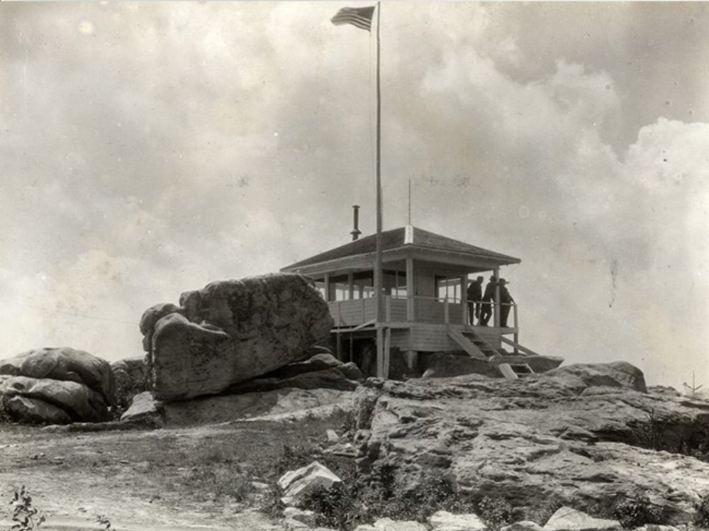
Top: The fire tower at Canaan Loop Road, which was decommissioned and disassembled in 1946. Photo courtesy USDA Forest Service.
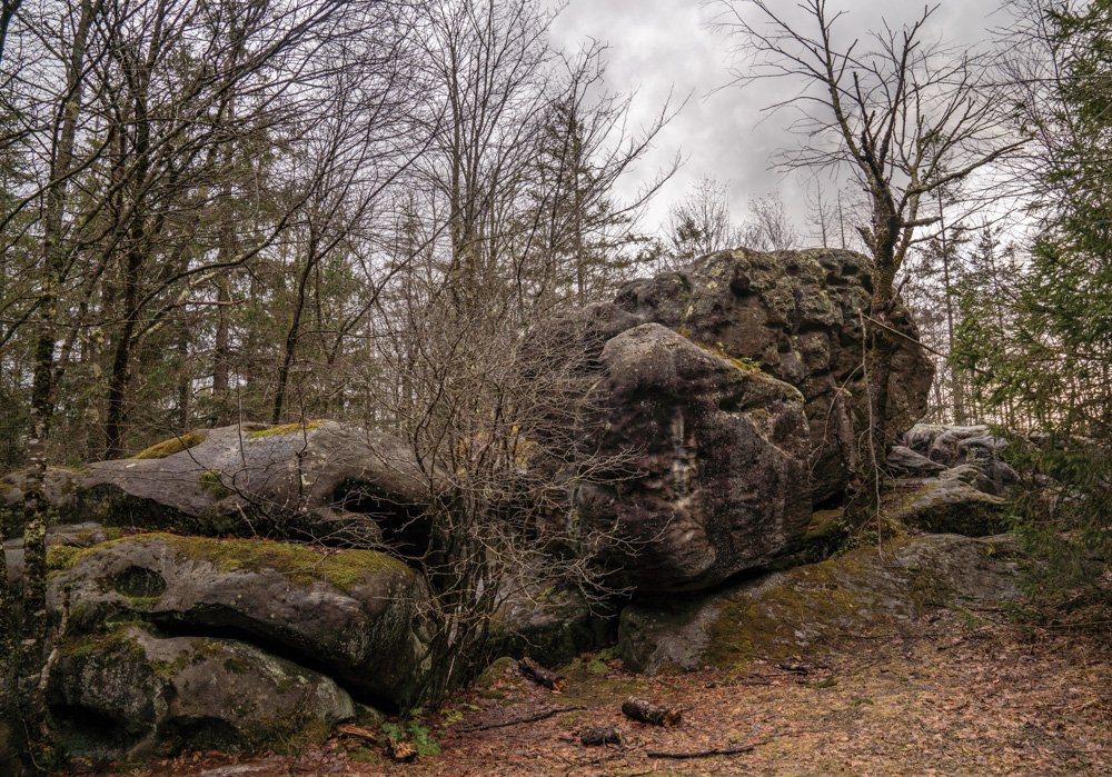
Bottom: The same boulder in 2025, surrounded by a mature forest. Photo by Dylan Jones.
During the inaugural planting camp in the spring of 1925, workers planted seedlings near the site of the former Canaan Mountain fire lookout cabin on Forest Road 13, which sat directly atop a massive boulder and offered a commanding view across the plateau. The fact that one could see for miles from a structure just 10 feet off the ground offers insight into just how barren the mountaintop was at the time. As the seedlings grew, the structure’s low vantage point rendered it useless as a fire lookout tower. A taller tower was erected just to the north and the existing cabin was decommissioned in 1946—the only remnants are a few chunks of concrete rubble where the footers were placed in the sandstone.
Standing atop the boulder, staring into the thick forest, it’s hard to believe the view once extended for miles. As I walk around where the cabin once stood, I imagine all the souls that set foot here while searching for signs of fire. Some of West Virginia’s wildest places that lie scattered throughout the million acres of the Mon were once buzzing hubs of industrious human activity. It’s always striking to me how much can be built and then removed by humans—and reclaimed by nature—in a single human lifetime.
Planting camp started in April each year as winter’s grip was still too strong upon the mountaintop in March. Seeds were brought up from local forest service nurseries along the rushing waters of the Cheat in Parsons and the Glady Fork in Gladwin, while some seeds for Norway spruce seedlings came all the way from their native Norwegian forests. Crews used handtools, like the Hazel hoe, for both tree planting and wildfire fighting, planting around 600 trees per day. They used the center hole method, which dictated that trees be planted six feet from one another in rows six feet apart.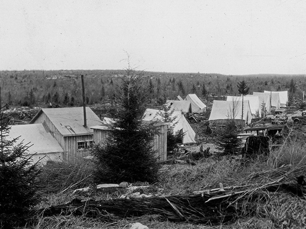
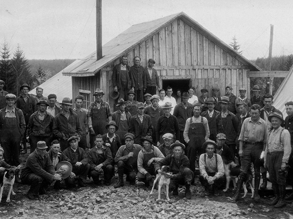
Top: A planting camp on Canaan Mountain in spring 1933.Photo courtesy National Archives.
Bottom: The 1933 planting crew and camp staff in front of the wooden mess hall. Photo courtesy National Archives.
However, the exposed sandstone bones of the mountain presented planting challenges. The rockiest areas averaged about 600 trees per acre while more fertile plots allowed up to 1,200 trees per acre. I’ve enjoyed volunteering for red spruce planting events in and around Canaan Valley over the years, and although the dibble is a more popular tool nowadays for planting red spruce seedlings, the methods remain the same as they did a century ago. It’s a unique experience to plant six-inch seedlings in view of 100-year-old trees that were planted by human hands. After a day’s work, it’s rewarding to look around at a plot of several hundred seedlings and imagine what they’ll look like after I am long gone.
The logging camps atop Canaan Mountain offered barebones accommodations and backcountry conditions typical of the era. Canvas tents, wood for tent floors, and coal-burning stoves were hauled up to the site of each spring’s planting camp. Wooden-walled mess halls were eventually added, which must have felt luxurious to the laborers at the time. Telephone lines were extended down Forest Road 13 to permit communication about progress, resupplies, and fire conditions with the district ranger.
From 1925 to 1933, exactly 1,559,300 seedlings were planted across 2,462 acres on Canaan Mountain. The majority were Norway spruce and red spruce, which one can clearly observe while making the trek from east to west across the mountain. In some locations on the edge of bogs, eastern white pine and eastern hemlock dominate. Interestingly, a single acre of European larch—a deciduous conifer with characteristic needles that turn yellow in autumn—was test-planted in 1927, but only half of the 2,000 seedlings survived. This patch of larch can still be found if you know where to look on the outskirts of the plantation.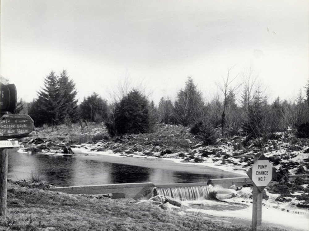
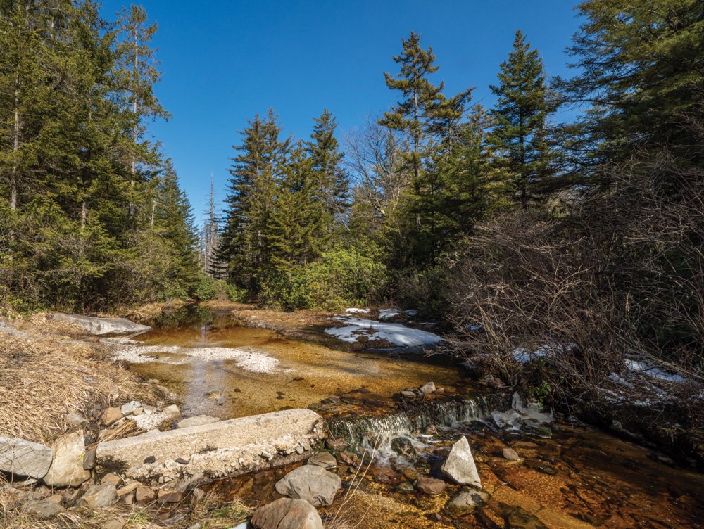
Top: Workers created small dams, called pump chances, along waterways to provide reliable water sources for wildfire mitigation. Pump Chance #7 was built along Red Run, just before it plunges down a steep canyon. Photo courtesy USDA Forest Service.
Bottom: 76 years later, the concrete dam of Pump Chance #7 is still visible where Canaan Loop Road crosses Red Run. Photo by Dylan Jones.
When planting ceased in 1933, the Civilian Conservation Corps stepped in to create a grid of fire control measures to protect the fledgling trees from the continued threat of wildfire. The grid of original fire trails allowed travel via jeep up and down the mountain’s north-facing slope. Fire breaks ran perpendicular to the fire trails and served to prevent wildfires from spreading. These trails are still in use today as recreational trails in the 13,000-acre Canaan Mountain Backcountry Area. Original trail names like Fire Break, Fire Trail #3, and Railroad Grade pay homage to the early days. The namesake Plantation Trail, which cuts from east to west for eight miles across the slope of Canaan Mountain, is considered one of the birthplaces of West Virginia mountain biking in the mid-1980s, and still sees use by avid riders who come to sample some of the Mountain State’s most rugged terrain on two wheels.
The reborn forest that now extends far beyond the plantation’s original borders supports a wealth of native hardwoods like beech, birch, cherry, and maple, plus a slew of unique high-elevation flora and fauna. As the forest continues to mature, it will undoubtedly change. I consider the plantation crews: how did they imagine the forest looking a century down the road? I often wonder what the ecological makeup of this mountain will be 100 years from now. Will it be mature forest? Will it be razed again? How will climate change affect the composition of species? Perhaps there will be a new era of citizens who rally to course-correct the short-sighted decisions of our era.
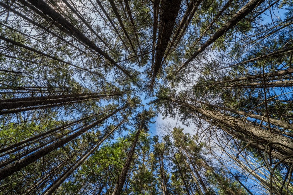
May these canopies continue to rise above us. Photo by Dylan Jones
As a denizen of Davis, this mountainside is my backyard, and I take advantage of this incredible public resource every chance I get. While millions of acres of West Virginia have been reforested over the years, it’s fascinating to regularly visit a place where the first concerted efforts to reforest the Mon began a century ago.
When I head out into the wild, I often think about the plantation crews. I imagine a hardscrabble life filled with dangerous hazards and harsh conditions, but I also like to think that these men had a sense of pride and purpose in what they were accomplishing. I wish I could construct a time machine, travel to the first spring camp, and transport the crew members back to the future to experience the forest in its present state. I imagine their reactions as they gaze up at the towering canopies and hear the flute-like song of a hermit thrush. I’d hug them and thank them for their herculean efforts. I like to think that they’d break down in tears of awe and joy as they gazed upon the successes of their seedlings.
Dylan Jones is co-publisher of Highland Outdoors and wishes he could be around in 2125 to see what West Virginia’s high-elevation forests look like, but he’d be 140 years old, so that ain’t gonna happen!